Cities in the Sky (Full Episode) | Lost Cities with Albert Lin Compilation | National Geographic
Chapters8
Explores the origin of Eldorado legends and how modern tech can illuminate hidden pasts.
Albert Lin uses aerial LiDAR and ground-truth digging to reveal lost mountain cities like Ciudad Perdida and Wat’a, tracing their pre-Inca to Inca transformations with stunning 3D visuals.
Summary
National Geographic’s Cities in the Sky blends high-tech archaeology with bone‑dry grit as Albert Lin and a team chase lost cities across continents. In Colombia, LiDAR strips away jungle to expose the terraces of Ciudad Perdida, revealing a dense social network once hidden by centuries of growth. The episode then shifts to Jordan’s Sela, where Lin, Mohammed Najjar, and a LiDAR crew show how rainwater harvesting tanks carved into rock supported a Nabatean metropolis atop a desert plateau. Back in Peru, Wat’a on a high Andean peak becomes a laboratory for comparing pre‑Inca and Inca occupancy with drone LiDAR and ML-driven feature detection. Across these sites, the team emphasizes a shift from nomadic beginnings to permanent settlements, weaving together geology, water engineering, and monumental architecture. Along the way, LiDAR is shown not as a replacement for boots-on-the-ground archaeology but as a way to map vast terrains and uncover guiding patterns that ground-truth confirms. The narrative ties these discoveries to a broader arc of how civilizations grew from mountain and desert aloofness into the iconic cities we study today. Lin’s journey culminates in a reflection that Petra’s prominence is the culmination, not the start, of the story of lost cities—with new clues clearly pointing to origins still waiting to be found. Overall, the episode champions the promise of 21st‑century tech to illuminate the past while reminding us that careful excavation and context remain essential.
Key Takeaways
- LiDAR can reveal flat, terraced areas (white on the model) that indicate human modification under dense jungle, enabling rapid identification of candidate sites at Ciudad Perdida.
- LiDAR-driven ground truthing at Sela uncovered 51 underground rainwater tanks, estimated to hold about 200,000 gallons to sustain 1,000+ residents.
- Pre-Inca and Inca layers at Wat’a are distinguishable via terrace patterns and pottery, with ML-assisted circular feature detection highlighting possible pre-Inca remains before later Inca construction.
- The narrative argues that Petra is the end of a longer story—the Nabatean origin site at Sela and other prehistory clues hint at a broader arc of desert urbanism and water engineering.
Who Is This For?
Essential viewing for archaeology enthusiasts, field scientists, and history buffs curious about how modern scanning tech reshapes our understanding of ancient cities and their emergence in harsh landscapes.
Notable Quotes
"The LiDAR scanner shoots about 400,000 laser pulses every second."
—Explanation of the LiDAR technology capabilities used in Ciudad Perdida.
"Without the trees, we can see Ciudad Perdida as it was 500 years ago."
—Demonstrates the power of aerial LiDAR to reveal ground plan changes hidden by canopy.
"This is pre-Inca. But we need to look."
—Adan challenges the team to distinguish pre-Inca features from later Inca modifications at Wat’a.
"The first ever LiDAR survey of Wat’a has revealed intriguing features."
—Groundbreak findings on pre-Inca versus Inca layers using drone LiDAR.
"An island in the sky."
—Albert describes Wat’a as an elevated, mountain-top town later transformed by the Inca.
Questions This Video Answers
- How does aerial LiDAR help archaeologists locate lost cities like Ciudad Perdida?
- What signs differentiate pre-Inca from Inca layers at mountain sites such as Wat’a?
- Why is Sela considered an Nabatean precursor to Petra, and what evidence supports it?
- What new insights does LiDAR provide about Nabatean water harvesting at desert cities?
- Could LiDAR scanning change our understanding of Machu Picchu’s origins and its prehistory?
NabateansCiudad PerdidaWat’aSelaLiDAR arIal surveyDrone LiDARGround truthingPre-Inca civilizationsInca empireMachu Picchu origins
Full Transcript
ALBERT (over radio): The jungles of Colombia, South America... This is where the legend of Eldorado was born. Spanish conquistadors, they heard these local tales of a king near here who was covered in gold dust. And then the story, it just kept growing to describe entire cities covered in the stuff, deep in the jungle, high in the mountains. While the Spanish never found those fabled civilizations, they also didn't have the technology that we have today. ALBERT: My name is Albert Lin. And I look at the world in a unique way. I use 21st century technologies to look back into the past.
Check that out, I can actually fly through the secret ancient world. Lasers that scan deserts. Strip away dense jungle canopy. And scour the oceans to uncover the hidden worlds beneath. We're wading into unchartered waters. Now I have the military helping me find lost cities. New discoveries in the most awe inspiring places on earth. SANTIAGO: That's where pixels become reality. ALBERT: That fill the gaps in our story. Who we are. Where we came from. And the wonders we can achieve. ELIEZER: Here we are in the 13th century. ALBERT: Wow. This is carved out of the earth huh?
This is the new golden age of exploration. We know their secrets. ALBERT (over radio): The mountains ranges are so steep that the whole area is almost entirely cut off from the outside, like a lost world. Over the past 50 years the whole area was mostly dominated by local drug lords and the FARC guerrillas. But now that archaeologists are beginning to make their way back in, they're finding traces of these unbelievable civilizations once thought totally lost. Wow... It's literally a city in the clouds. Maybe those Spanish stories weren't just legends, because that's what a real Lost City looks like.
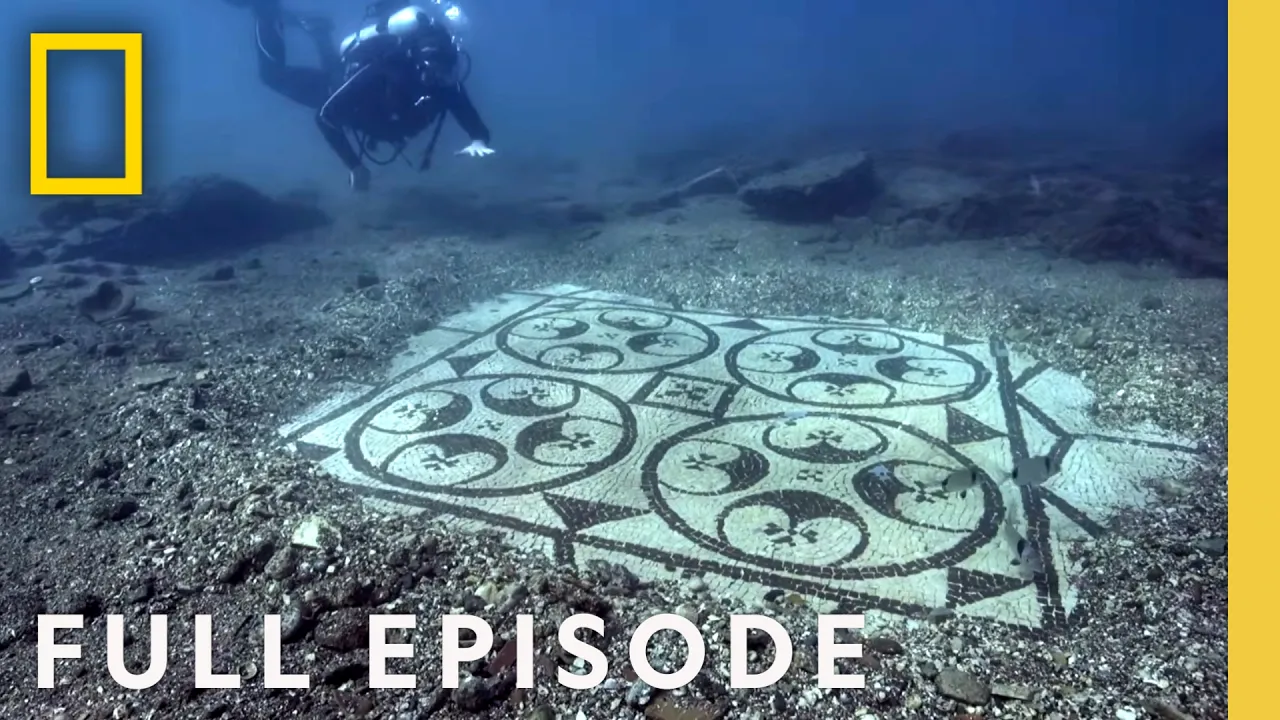
PILOT (over radio): 9-1-0-1-2 ALBERT (over radio): That's Ciudad Perdida, "The Lost City." ALBERT: Ciudad Perdida, the "Lost City", is high up in Colombia's most isolated mountain range, the Sierra Nevada. Archaeologists have spent decades exploring this dense jungle to find out about the people who lived here over 500 years ago. Digital technology will help them reveal more, and faster. Only the world's toughest archaeologists can handle this terrain. Santiago Giraldo has been excavating here for 20 years. (laughing). It's a beautiful place. It's amazing this place is still standing. Who built all this? SANTIAGO: It was a people that we call the Tairona, their predecessors.
It began to be built around 600 AD. ALBERT: It's huge. How many people would've lived here? SANTIAGO: About 2,000 to 3,000 at its peak, and then about 10,000 people living in the upper part of the basin. ALBERT: 10,000? SANTIAGO: Yeah. All that forest that you see would've been all farmland. ALBERT: Oh man, you can almost feel their energy here, you know, like, all these people running around. SANTIAGO: It's taken us over 40 years of work to clear out and survey the site, trying to tease out what these people were thinking when they were building it.
ALBERT: 40 years? The reason why, soon becomes clear. The Tairona built their homes on the steepest ridges of this thick, dense, jungle. From here, they could see everything around them. Safe in the mountains, they remained hidden for centuries. They're one of the most mysterious people in all of South America. And finding their ancient cities in this terrain is almost impossible. These roots are incredible. SANTIAGO: Yeah, it's a fig tree. This is what I wanted to show you. See that right there? ALBERT: The rocks? SANTIAGO: See that? Yeah. ALBERT: Is that a wall? SANTIAGO: Yeah, it's a wall.
It's a wall, it's a Tairona wall. ALBERT: Wow. It's incredible. ALBERT: I mean you barely recognize it. SANTIAGO: Well you know, we've got like 400 years of growth and leaf litter and soil. ALBERT: I think there's a better way to do this. We could use aerial LiDAR to do a digital model of the whole place. And then we could remove the trees and see the ground. We could find the pathways, the rockpiles, the walls. SANTIAGO: That would be amazing. If it does pick up these terraces, it would be really, really amazing. It would be fabulous.
ALBERT: Maybe we'll even find some new ones. LiDAR should be able to strip away the trees to expose the ground beneath them across this whole area. Including terrain that has yet to be explored. The LiDAR scanner shoots about 400,000 laser pulses every second. Each pulse creates an accurate distance measurement, which we can use to build a 3D model. This has never been tried here before, we're in totally uncharted territory. We don't know what we'll find. it could be more lost cities or it could be nothing. But what we do know is that this chance is just too good to miss.
(whirring). We mount an aerial LiDAR scanner with three lenses on a helicopter. One lens faces straight down, the other two are at angles. This maximizes the chance that some of the laser beams will make it through the canopy to the ground. The aerial LiDAR team gets to work, scanning and processing billions of data points from the valley. Using the LiDAR data, we've built a 3D model of Ciudad Perdida. Here it is. SANTIAGO: LiDAR data's in? ALBERT: Yeah, this is the whole scan. SANTIAGO: Oh my god, okay. ALBERT: And look at this, ready? Boom. Without the trees, we can see Ciudad Perdida as it was 500 years ago.
Transported through time, we can move through the city following the footsteps of the people that once lived here. SANTIAGO: This is amazing. You've got like the center part of the town and then all these paths that lead out to it and connect to the other neighborhoods. Imagine, you've got dogs, you've got kids playing, you've got goldsmiths, weavers, you've got merchants... Yeah. This is Ciudad Perdida. Everything you see in white, that's flat. That's what we're looking for. ALBERT: That's the signature of... SANTIAGO: Yeah 'cause white means flat, flat means humans and that means terracing. So what we're looking for is white.
Oh look, look, you can see right there the path that leads up river... Can you pull out a bit more? ALBERT: Okay. SANTIAGO: I want to see more. I want to see more, see if we can find some new areas. Oh, look, this is new, this is absolutely new. ALBERT: Wooow! SANTIAGO: Right there. This is new. This area right here. Right there, right there, that ridgeline right there, this area right there. See that, it's nice and flat, it's highly probable that there is terraces right there... This is... this... we've never been there. ALBERT: So you're telling me that this area up here could be an entirely new city or site?
SANTIAGO: Yeah, it could be a new site, could be a new town. This is this is fantastic data. ALBERT: A lost city in the mountains, that you've never seen before? SANTIAGO: Yep. Could be. But we need to ground truth 'em, we got to put boots on the ground, and head out there and see for ourselves whether there's terracing and walls and just manmade structures. That's where ALBERT: Somewhere out there, there's a lost city waiting to be found. ALBERT: This going to be tough. We'll be bushwhacking through some of the world's roughest terrain. Santiago and I head off with the camera crew.
We've got the Colombian military with us, because bandits still roam this jungle and we can't take any chances. Before we even can start the climb, there's a long trek on the old Tairona path. Then it's hours of bushwhacking up the ridge we spotted on the LiDAR scans. Our goal is to get to the top of the ridge where the LiDAR showed large flat areas, that we hope are the signs of a Tairona city. It starts so well. Wow. It's just so beautiful... But it's not long before the real challenge begins. We're literally following a map made by lasers in the sky through the thickest jungle I've ever seen to look for new lost cities.
SANTIAGO: Good fun. Good fun. ALBERT: We leave the old Tairona path and start to fight our way up the mountain. This climb is harder than we could have ever imagined. Sorry. Oh, oh oh! You alright? After a brutal climb, we finally have a breakthrough. SANTIAGO: Oh, there we go. (speaking Spanish). We got lots of pottery up here. ALBERT: Pottery? ALBERT: You serious? SANTIAGO: Yeah, yeah. Yeah. Look at that. Bits and pieces of pottery right there. ALBERT: Oh yeah. Look at that. SANTIAGO: See? Can you get the trowel out please? Here we go. ALBERT: Ancient pottery.
SANTIAGO: See this one right there? ALBERT: Where there's pottery... SANTIAGO: There's human beings! ALBERT: This is Tairona pottery. This is so cool. We follow the trail of pottery uphill. SANTIAGO: Terraza, terraza. We've got a terrace up here. C'mon. ALBERT: You got a terrace? SANTIAGO: Yeah, yeah, yeah. ALBERT: We found a terrace. What! SANTIAGO: Yeah yeah yeah. ALBERT: Already. SANTIAGO: Yeah. You can see the wall right here... can clear that a bit. See right there? ALBERT: Let me see. SANTIAGO: Yeah, there it is. See, wall, wall right here. SANTIAGO: See the big blocks of stone right here.
ALBERT: Mmhmm. SANTIAGO: You can hear the clink of stone, stone, stone, stone right here. More stone right here. Stone. ALBERT: So you've never seen this before? SANTIAGO: No, we've never seen this before. We've found 3, 4, 5 terraces? ALBERT: Yeah! SANTIAGO: Alright! ALBERT: These terraces are a sign that the Tairona were once here. But the site we spotted on the LiDAR scan is still far above us. We're not even halfway there. This climb is unrelenting, we're all struggling. It's merciless and unforgiving. If there's a city here, then it will have been built on a huge, artificially flat space, the white areas we saw on the LiDAR scans.
You see anything? SANTIAGO: Oh yeah. This is flattening out. Watch out. ALBERT: We're on a terrace? It's, we've got a lot of forest over it but, yeah. That's all nice and flat. ALBERT: The flat area looks like it could be a Tairona terrace. But to be sure, we need evidence: pottery, cut stones, anything to show the Tairona actually lived here. ALBERT: Without cold, hard proof that the Tairona were here, we'll have done all this for nothing. I see a rock right here. This is a piece of cut rock, just like at Ciudad Perdida. Following it, let's see if we can see it on the other side of this tree.
SANTIAGO: Do you see it over there? ALBERT: Yeah, it continues over here. SANTIAGO: Good. Yeah, yeah. ALBERT: This? SANTIAGO: We got that one right there. Yeah. ALBERT: Another piece of cut rock. You think this is the edge of a terrace? SANTIAGO: Yeah, I mean the line goes that way, the line goes that way. So that's why we've got that flat area right inside. This is what we're looking for. The edges of it. ALBERT: There's stone after stone after stone. SANTIAGO: Yeah, we've got another one over here. ALBERT: You've got another one? SANTIAGO: Yeah, we got another rock over here, yeah.
A bit of the wall has tumbled down... ALBERT: I think we've found it. SANTIAGO: I've got pottery! ALBERT: What? You serious? SANTIAGO: I've got pottery, yeah, yeah. Definitely. It's a really small piece. Can you get some water and clean it up but, yeah. It's pottery for sure. ALBERT: Wow, look at that. The tiniest fragment, but it's enough. SANTIAGO: This is going to be fun to excavate. Pottery for sure. ALBERT: This was once somebody's home! This city would have been part of the great Tairona civilization from mountaintops to the sea. The LiDAR scans uncovered this extraordinary place, reclaimed by nature and hidden under the jungle for hundreds of years.
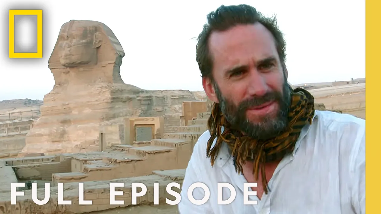
And this is just the beginning. With this technology we can discover dozens of new cities and possibly the whole Tairona civilization. Ever since I first saw this, the magical city of Petra in Jordan, it just hasn't left my mind. It's one of the most beautiful, unusual and iconic cities in the world. But I've learned something surprising. Petra is not the beginning of the story. It's the end. There's another lost city carved into the rock, somewhere near here. I'm hoping to find the hidden origins of one of the greatest cities the world's ever seen. The people who lived here, in this city, they were originally nomads.
Traveling, trading across the Arabian desert. Living in tents. And then in a leap they built this. What happened? I wanna find out who they were, where they came from. And what came before all this. New clues about them are being discovered in the desert rocks. ALBERT (over radio): We're now flying over the Jordanian desert. In a Black Hawk. ALBERT: Bob Bewley is an aerial archaeologist. He traces the ancient water sources and trade routes of the Nabateans from above. ROBERT (over radio): Can you see the track there, Albert, on the left hand side? ALBERT (over radio): Where?
ROBERT (over radio): Along the ridge there. Right there. And although we're looking at a modern road, it's built on the ancient road. And now we're gonna follow it. ALBERT: Ancient writings suggest that somewhere along this highway lies a Nabatean city, hidden in the mountains. One that pre-dates Petra by hundreds of years. Oh it's gotta be this. I can see the modern highway. But you see the ancient highway running right next to it. ROBERT (over radio): Level off, level off straight ahead. That's it, lovely. So that's the track running up the hill there. So that'd be the road?
Yeah yeah, yeah yeah. ALBERT: We approach a barren mountain top. Surrounded by steep valleys. That's lovely. 11:00. Right here? ROBERT (over radio): Yeah. Okay I see it. ALBERT: This rocky plateau doesn't look like any lost city I've ever seen before. But the ancient Greek writings describe the nomadic Nabateans setting up home here. Possibly for the first time. ROBERT (over radio): Happy to land? Yeah, yeah. Fantastic. ALBERT: The city is called Sela. Hebrew for rock. ALBERT (over radio): Incredible. That's amazing isn't it? Look at that, just... ALBERT (over radio): We've just landed on the ancient highway.
ALBERT: Sela has never been scanned by lasers before. I'm launching an expedition to the summit. 3000 feet above sea level. With my LiDAR team. To uncover the secrets of this mysterious place. ALBERT: The LiDAR team and I are heading to one of the last fully unexplored Nabatean sites. And Jordan's acclaimed archaeologist, Mohammed Najjar, is leading the ascent. (speaking Arabic). ALBERT: How are you my friend? MOHAMMAD: Hi, good to see you. ALBERT: Yeah, it's been too long. MAN: I've never carried LiDAR kit on a donkey before. Or on a horse. ALBERT: This is high tech meets ancient tech.
MOHAMMAD: Yeah, yeah. ALBERT: Are you ready? Let's go. (speaking native language). ALBERT: I don't know what to expect at the top. What I do know is we're heading to 3000 feet above sea level and it's gonna be a tough climb. It's like a maze. MOHAMMAD: Yes it is. ALBERT: Those steps, are those... MOHAMMAD: Yes that's our way up. AHMAD: This is the only way to climb to Sela. There's no other way. ALBERT: The steps are the first hint that this bare mountain has been shaped by people. Gotta be 90 degrees out here right now. MOHAMMAD: Yeah.
Watch what you do. ALBERT: This is like an ancient skyscraper up here. The terrain is brutal. And the questions keep coming. It just seems like an unbelievable amount of effort to build your world on top of a mountain, in the middle of an arid desert. Shall we take a break and drink some water guys? Stay away from the mean donkey. You know water is like, it's how you live. But this desert is so dry. How do you survive on top of a mountain? Surrounded by dirt and no rivers nearby? Nothing to farm. How could you hold out?
Feels like we're getting close. This way huh? Finally we reach the top. But how did this lifeless crop, with no water source, become home to a city of people? To hunt for clues we plan to LiDAR scan the whole plateau. MAN: The access to so much of it is virtually impossible. ALBERT: It also looks like sheer drops everywhere. Deadly basically to explore. MOHAMMAD: Absolutely. ALBERT: So hopefully we can go places that wouldn't be safe to go otherwise. MAN: Okay we're good to go. ALBERT: This is a very dangerous place to fly. MAN: It's a risky location yeah.
We're gonna have to have all eyes on the drone at all times. ALBERT: This is like super advanced drone flying. MAN: Yeah. super, super expert model. MAN: This is level ten sure. ALBERT: It's hard to believe this barren place was once home to hundreds, even thousands of people. If they left any evidence I'm banking on my technology to find it. So we hiked up here. Right? MOHAMMAD: Yes. ALBERT: It's a lot easier from a computer isn't it? MOHAMMAD: Yeah it is actually yeah it is. I think this is the way to look at the site because if you look at small parts you cannot understand.
We need to look at the whole site together. And then you can understand the dynamics. ALBERT: Looks like it's starting to be shaped by human hands. MOHAMMAD: That's true. That's true. I mean look at that. Look at this picture. ALBERT: The LiDAR data reveals water tanks cut into the rock. Almost invisible to the naked eye. After three days of scanning we've logged an incredible 51 underground tanks. Here at Sela it's the first time anyone has uncovered the extent of rain water harvesting. MOHAMMAD: We have to channel the water, the rain water the run-off from the face of the rock to the systems.
ALBERT: We can now estimate that these man made tanks contained about 200,000 gallons of rain water. Plenty to sustain over 1,000 permanent settlers. It's an exciting discovery. MOHAMMAD: They were nomads at the beginning. They were like wind you know, and they... And then they, there was a shift in their consciousness. I mean they started to be attached to the land. ALBERT: They're turning the landscape into a home. A permanent home. Our LiDAR data transforms what we know of Sela. The Nabateans ingenuity and knowledge of water enables them to settle, living together in a permanent city here in the dry, rocky desert.
It's a stepping stone to Petra. The journey has begun. Machu Picchu, once a, a vast ceremonial city perched high up in the Andes. Built in the mid 15th century, it was the crowning glory of a vast Inca empire. But its origins, they're shrouded in mystery. The genius that led to the creation of this iconic city started somewhere. Where there is an end, there is also a beginning. And I intend to find it. ALBERT: Were those mighty Inca warriors, were they standing on the shoulders of giants? Of earlier civilizations? Armed with 21st century technology, I'm headed deep into the Andes to find out.
Before the Inca, Peru was inhabited by smaller, competing tribes. Maybe finding evidence of these people will point me in the right direction. I'm headed to an Inca site that's both older and higher in altitude than Machu Picchu. Oh, it's my caballo. Hello. We're headed to that peak at 13,000 feet of elevation, it's gonna be a trek. And we've got a lot of gear. The Inca buildings at Wat'a are around 100 years older and at an altitude 5,000 feet higher than Machu Picchu. Tom Hardy and Peruvian archaeologist Adan Choqque Arce are joining me. There's horse poop everywhere.
Low tech transport empowers high tech gear. To help us reveal why the Inca built and ruled here. Wat'a is more than twice the height of Mount Rushmore. The air is thin and the going is tough. We're at 11,600 feet of elevation. We got a ways to go. Steep drop right off here. About 1,000 feet from the top, imposing Inca walls loom into view. The structure feels familiar. Whoa. Look at this place. (gasping). How could they build in such an intense environment? You have to be born with super lungs. THOMAS: Well, they got 'em. When you're, when you're born here and you're raised here.
It's easier to move around, right? ADAN: I think it was easier for me. THOMAS: The hardest part for him was waiting for us. ALBERT: Oh wow. ADAN: Wat'a, it means in the local language, an Island. ALBERT: An island? ADAN: Yes. ALBERT: An island in the sky. THOMAS: Really is pretty impressive view from up here, isn't it? The Inca came, put this wall up here. They transformed the site, made it into an Inca place. ALBERT: So this was all here before the Inca even showed up? THOMAS: Part of it. A lot of this is Inca construction on top of the earlier settlement.
ALBERT: We know from Machu Picchu that the Inca built high to assert their authority. And this place is high, more than one and a half times Look at this. This is the top. Look at this view. THOMAS: This is pretty impressive. ALBERT: Why would they build something like this? This high up in the mountains? THOMAS: Well, we have some ideas based on the relationship of the landscape. ADAN: I think people living here thought that they came from the mountains and the mountains was their ancestors. ALBERT: The mountains being the ancestors? The actual mountain being a being that humans are born from is that, is that correct?
ADAN: Like a person it was their, their father, their ancestor, their grandfather. THOMAS: They become these objects of sacred veneration and respect. ALBERT: Not only to the Inca but to the people even before the Inca then? THOMAS: Probably. Yeah. ALBERT: We're standing here on a mountain top, just like Machu Picchu was on a mountain top. Yet, unlike Machu Picchu, there might be evidence of activity here before the Inca. THOMAS: Yeah. ALBERT: So why don't we take our technology and try to scan the entire mountain top? Really make every little piece of evidence of that existence pop back out to life.
THOMAS: Mm mm. I think we should try. ALBERT: The mountain has been surveyed before. But this'll be the first time it's ever been scanned using LiDAR. We hope to uncover new finds, both Inca and pre-Inca. How does this look for our base to set up? DUNCAN: Precarious. ALBERT: Yeah, let's just be really careful about the edge here. DUNCAN: Certainly good for LiDAR, I mean, look at the view off there. You're looking straight down onto, onto rock outcrops and bits of masonry already. ALBERT: Look at those edges, it just falls off into nothingness, huh? DUNCAN: It's gonna have to be so careful with the flights and stuff.
ALBERT: We have never used our drone based LiDAR at an altitude of 13,000 feet before. And you got thin air up here too, right, so it's trickier flying. JOSEPH: Totally. Super tricky, I mean, we've got the high altitude props on there, which help. But still if you lose a done, it's a sheer drop. ALBERT: Hopefully with this survey, we can delete all of that grass and see what's really there. What's hidden beneath that veil. JOSEPH: It's up. ALBERT: Our drone survives the extreme altitude and data processing gets underway. As darkness falls on Wat'a, the results are in.
JOSEPH: So this is all of the aerial LiDAR combined. This is with the vegetation on, so this is the point cloud as captured, basically. ALBERT: Yeah. ADAN: Mm. ALBERT: Then let's delete it, ready? Wow, look at that. JOSEPH: Yeah. ADAN: Wow, it's impressive. increible. ALBERT: It looks like the whole range has been carved. JOSEPH: That's really cool. ALBERT: The LiDAR reveals signature Inca terracing. This area here, you think is mostly augmented by the Inca, is that right? ALBERT: So, in the most simple terms, what are we looking for feature-wise that might be from before the Inca?
THOMAS: The most basic signature that we would be looking for would be the foundations of circular structures. ALBERT: Mm mm. THOMAS: And these, these could appear quite obviously but they also could be a little more sort of destroyed or moved around by vegetation growing through the stones. ALBERT: You think we can actually use the machine learning computer vision algorithm to look for circular features? JOSEPH: Yeah, definitely we can highlight the features based on a few different elements. ALBERT: How long will that take? JOSEPH: Should be able to spin something up for you right now. ALBERT: I knew you would.
JOSEPH: There we go. ALBERT: What is that? THOMAS: It could be one of em. Yeah, looks like it's on a bit of a terrace. ALBERT: Does that look to you like something pre-Inca? ADAN: Yeah, I think so. ALBERT: I didn't see any of this today. I couldn't have seen any of these features from walking the ground. So if you can spot out any details that might look possibly pre-Inca, then we should go there tomorrow. We'll just geotag them and we'll go there with a GPS and find all of them. ADAN: I think it'd help us a lot, to archaeologists to find where the structures are.
ALBERT: Great work. Good job guys. The first ever LiDAR survey of Wat'a has revealed intriguing features and they need ground truthing. Is it circular? ADAN: It could be pre-Inca. But we need to look. ALBERT: Well, what we're trying to find, is anything that tells us what happened here? What would this have been for? Is it like a well or something? Or storage? THOMAS: It could be storage. ALBERT: Adan, you're like the ceramics whisperer, you find stuff everywhere. Do you think you can find anything? ADAN: OK, well, (inaudible). ALBERT: Looks like there's bits of ceramic all right back down there.
THOMAS: Here's some, oh here we go. Looking at the fabric and looking how eroded and soft it is, I would guess it must be Pre-Inca because the Inca stuff is really well fired, it's really hard. It endures very well. ALBERT: Well, let's see if we can find more. If there's more points on the, on the data. THOMAS: Yeah, let's do it. ALBERT: We zero in on a large terraced area. Oh this looks like one of their circular pits. This is probably an opening. So this could have been an entry point here. And would have built up above it.
ALBERT: Look at that right there, what's that? You got a piece of pottery? ADAN: It's of a cooking pot. THOMAS: It's like the burned up, banged up metal pot you'll find in your mom's house, yeah. So food was cooked here. You can almost smell it. Where do you think it came from? could be before the Inca. ALBERT: This is pre-Inca? pre-Inca, yeah. ADAN: I think it was a house for a family. ALBERT: Really? ADAN: Mm mm. ALBERT: So could this be the residential area for this entire site? THOMAS: This certainly suggests that might be the case for the pre-Inca period.
ALBERT: Just on the other side of what looks like a plaza, are some square buildings that appear to have been built later. THOMAS: Look at this. ALBERT: So this is Inca? ADAN: Yes, definitely. ALBERT: You could literally set up shop anywhere. Why would they build this here? Right on top of the prior? ADAN: Before the Inca, it was a public place, public space. The Inca came and interact with the pre-Inca. THOMAS: The Inca would have been hosting here, bringing in people to make them feel part of the community with food and drink suggesting this area was an important place for all sorts of events going all the way back to the very beginnings of this site.
ALBERT: It's as if the Inca, they came, they saw people living here. And they incorporated their beliefs but in a much larger scale. And they completely modified the top of this mountain. So when they were building Machu Picchu, they would have known about this place. THOMAS: Yeah, a lot of the things we see here, the way that the, the mountain side is completely terraced, all of that is very similar to what we see at Machu Picchu. ALBERT: There's a belief system that I've learned that threads through time here. A belief that people come from the mountains, people come from nature.
Through time, that belief has evolved into the architecture that you see today here, at Wat'a. It's an island in the sky. For the first time, LiDAR data reveals the complete picture of the monumental scale of Wat'a and the efforts of human hands that carved this mountain. Once a pre-Inca, ancient mountaintop town. Imagine this transformed by the Inca. Imposing residential areas, ceremonial plazas. And grand terracing. This is the city of the living I have been searching for. Captioned by Cotter Captioning Services.
More from National Geographic


Get daily recaps from
National Geographic
AI-powered summaries delivered to your inbox. Save hours every week while staying fully informed.